Our Africa map collection from publishers across the globe is a treasure trove for map lovers and African expatriates. You can get maps of all African countries like Algeria, Sudan, Libya, Kenya, and many more. Whether you need a map for referential purpose in your office, educational use in classrooms, or for wall decor in homes, you can get one delivered to your doorstep.
Map of Africa
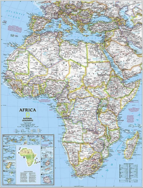
This Africa map shows the total land area of the continent i.e 11,730,000 square miles. You can also view the exact location of the continent that is bounded by the Atlantic Ocean in the west, the Mediterranean Sea on the north, the Red Sea by the east and the Indian Ocean on the south. It also shows major cities and regions of the continent with international boundaries and oceans.
Here you can find Africa divided into five regions or subregions(four of which are in Sub-Saharan Africa).
These regions are:
- Northern Africa
- Northeastern Africa
- Central Africa
- Northwestern Africa
- Southern Africa
1. Map of Northern Africa
This region encompasses the northern portion of Africa. It stretches from the Atlantic shores of Morocco in the west to Egypt’s Suez Canal and the Red Sea in the east. The area is further divided into three main geographic features: the Sahara desert, the Atlas Mountains, and the Nile River.
The 6 countries that shape Northern Africa are Algeria , Egypt , Libya , Morocco, Sudan and Tunisia. Among which Algeria and Libya have transformed their economies after the discovery of oil and natural gas reserves in the deserts. Egypt, however, has the most varied industrial base as it imports technology to develop electronics and engineering industries. It also has the reputation of its high-quality cotton textiles and is a famous tourist destination.
| Countries | Capitals | Facts and Figures |
| Algeria | Algiers | It is the largest country in Africa |
| Egypt | Cairo | Approx 90% of Egypt is desert |
| Libya | Tripoli | It has the longest Mediterranean Sea coast of any North African country |
| Morocco | Rabat | It is one of the oldest recognized countries in Africa |
| Sudan | Khartoum | The place is known for the world’s largest collection of pyramids |
| Tunisia | Tunis | It covers a 1,148 kilometers (713 miles) of coastline |
2. Map of Northeastern Africa
The region of Eastern Africa consists of two traditionally recognized regions: East Africa, made up of Kenya , Tanzania , and Uganda and the Horn of Africa, made up of Somalia , Djibouti, Eritrea, and Ethiopia .
It is composed of mainly plateaus and has most of the highest elevations in the continent. The world’s second-largest freshwater lake, Lake Victoria and the second deepest lake, Lake Tanganyika can also be found in this region.
The major countries that form this region are listed below with their location and capital cities.
|
|
Countries |
Capital |
|
Horn of Africa It is a peninsula in Northeast Africa that extends hundreds of kilometers into the Arabian Sea and lies along the southern side of the Gulf of Aden. |
Djibouti |
Djibouti City |
|
Eritrea |
Asmara |
|
|
Ethiopia |
Addis Ababa |
|
|
Somalia |
Mogadishu |
|
|
Countries |
Capital |
|
Nile Valley The Nile is a north-flowing river in northeastern Africa and is an “international” river as its drainage basin covers 11 countries. |
Sudan |
Khartoum |
|
South sudan |
Juba |
|
|
Countries |
Capital |
|
Indian Ocean Islands It is the third-largest of the world’s oceanic divisions that is bounded by Asia, Africa, and Australia. |
Madagascar |
Antananarivo |
|
Mauritius |
Port Louis |
|
|
Comoros |
Moroni |
|
|
Seychelles |
Victoria |
|
|
Réunion |
Saint-Denis |
|
|
Mayotte |
Mamoudzou |
|
|
Countries |
Capital |
|
East African Community This intergovernmental organization is composed of 6 countries in the African Great Lakes region in Eastern Africa. |
Uganda |
Kampala |
|
Rwanda |
Kigali |
|
|
Burundi |
Gitega |
|
|
Kenya |
Nairobi |
3. Map of Central Africa
Central Africa consists of 9 countries according to different definitions. This entire region is known for farming, herding, and fishing activities.
The Lake Chad basin has been ecologically significant to the populations here as it served as an important supra-regional organization. Fisheries in this lake basin have provided food and income to more than 10 million people.
Countries in this region with their capitals are listed below:
| Countries | Capital |
| Angola | Luanda |
| Cameroon | Yaoundé |
| The Central African Republic | Bangui |
| Chad | N’Djamena |
| The Democratic Republic of the Congo | Kinshasa |
| Republic of the Congo | Brazzaville |
| Equatorial Guinea | Malabo |
| Gabon | Libreville |
| São Tomé and Príncipe | São Tomé |
4. Map of Northwestern Africa
North West Africa comprises 16 countries and has an estimated population of 362 million. The northern part of this region is composed of semi-arid terrain called the Sahel. It is a transitional zone between the Sahara and the savannahs of western Sudan.
Few major countries of Western Africa are listed below:
| Countries | Capital |
| Mali | Bamako |
| Mauritania | Nouakchott |
| Niger | Niamey |
| Nigeria | Abuja |
5. Map of Southern Africa
The region of Southern Africa is variably defined by geography or geopolitics. It majorly includes 9 countries and a diversity of ecoregions like grassland, bushveld, karoo, savannah, and riparian zones.
The region also has the world’s largest resources of platinum and the platinum group elements, chromium, vanadium, and cobalt, uranium, gold, copper, titanium, iron, and diamonds.
Few major countries of Southern Africa are listed below:
| Countries | Capital |
| Botswana | Gaborone |
| Namibia | Windhoek |
| South Africa | Pretoria, Bloemfontein, and Cape Town |
| Zambia | Lusaka |
| Zimbabwe | Harare |
Summary
We tried to list every African country here on the basis of their regions. You can view maps of these countries by clicking on their names above. Every map in our collection of African Country maps highlights the political and physical features of the country. You can use them for business and references in your homes and offices.
Get these African Country maps delivered to your doorstep today!
