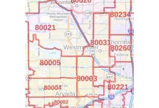
Northglenn Map
Map of Northglenn, Colorado uses the base map data from TomTom. The data is updated every 6 months making this one of the most updated printed large map of Northglenn and its neighborhood areas.
This map is available in a scale of 1:13,000 in 36 x 24 inches. If you want a map with different extents, orientation, or scale, you can do that by customizing the map here.
If you have any questions, we will be happy to answer over the phone (866) 525-2298 or write to us
This map is available in 24 x 36 in. Please select a finish of your choice
Please wait, adding to your cart
Please wait, initializing the product
About Northglenn, Colorado
Northglenn is the home rule municipality in Adams and Weld Counties, in the U.S state of Colorado. The City was built as a master-planned community in 1959 by Jordon Perlmutter. The City is directly connected to Downtown Denver via the forthcoming Regional Transportation District N line at Northglenn/112 station.
Facts and Figures of Northglenn, Colorado
Latitudinal and Longitudinal Coordinates- 39.53’51”N 104.58’55”W
Total Area- 7.5 squares miles (19.4 km2)
Total Land Area-7.4 square miles (19.2 km2)
Elevation-5,377 ft (1,639 m)
Zip codes-80233,80234,80241,80260
Area Codes- 303 and 720
More Maps
| SKU | svd_co_northglenn_24 |
|---|---|
| Map Scale | 1:13,000 |
| Flat Size | 24 x 36 in |
Write Your Own Review
Related Products


Nearby Locations
-
![Thornton ZIP Code Map, Colorado]() Thornton ZIP Code Map, ColoradoPrice from $41.99
Thornton ZIP Code Map, ColoradoPrice from $41.99 -
![Westminster ZIP Code Map, Colorado]() Westminster ZIP Code Map, ColoradoPrice from $41.99
Westminster ZIP Code Map, ColoradoPrice from $41.99 -
![Thornton Map]() Thornton MapPrice from $24.99
Thornton MapPrice from $24.99 -
![Westminster Map]() Westminster MapPrice from $24.99
Westminster MapPrice from $24.99 -
![Broomfield Map]() Broomfield MapPrice from $24.99
Broomfield MapPrice from $24.99 -
![Federal Heights Map]() Federal Heights MapPrice from $24.99
Federal Heights MapPrice from $24.99