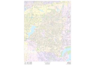
Grand Prairie Map
This map of Grand Prairie has been designed with accuracy based on well-researched data. The map highlights Municipal, town, and Zip code boundaries. Transportation routes (I-30, SH-180, SH-161) interlinking the cities of Texas, the USA is marked neatly in the map with color-coded markings.
Major infrastructure like colleges, airports, police stations, shopping malls, industrial complexes, hospitals train stations is also identifiable. A map legend featured at the bottom helps all the signs, characters graphics, and symbols used throughout the map.
About Grand Prairie, Texas
Grand Prairie is a city located along the border between Dallas County and Tarrant County, with a small portion extending into Ellis County, Texas, in the United States. It is part of the Mid-Cities region in the Dallas-Fort Worth metroplex.
The West Fork of the Trinity River and a major tributary, Johnson Creek, flows through Grand Prairie. The Zip code of the City ranges from 75050-75054.
Cities and Towns Bordering Grand Prairie, Texas
- Northwest- Fort Worth
- North- Irving
- East - Dallas
- Southeast- Cedar Hill and Midlothian
- West- Arlington
- Southwest- Mansfield
More maps of Texas Cities
| SKU | svd_tx_grand_prarie_24 |
|---|---|
| Map Scale | 1:19,000 |
| Flat Size | 24 x 36 in |


-
![Arlington, Texas Inner Metro - Landscape Map]() Arlington, Texas Inner Metro - Landscape MapPrice from $39.99
Arlington, Texas Inner Metro - Landscape MapPrice from $39.99 -
![Arlington, Texas - Portrait Map]() Arlington, Texas - Portrait MapPrice from $39.99
Arlington, Texas - Portrait MapPrice from $39.99 -
![Grand Prairie Zip Code Map, Texas]() Grand Prairie Zip Code Map, TexasPrice from $41.99
Grand Prairie Zip Code Map, TexasPrice from $41.99 -
![Irving Zip Code Map, Texas]() Irving Zip Code Map, TexasPrice from $41.99
Irving Zip Code Map, TexasPrice from $41.99 -
![Duncanville Zip Code Map, Texas]() Duncanville Zip Code Map, TexasPrice from $41.99
Duncanville Zip Code Map, TexasPrice from $41.99 -
![Arlington Map]() Arlington MapPrice from $32.99
Arlington MapPrice from $32.99