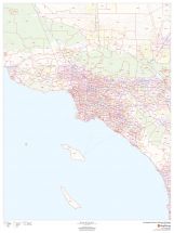
Riverside County Map (California)
The Riverside County map, California shows regional and street-level information. Base map includes highways, major roads, neighborhood names, railways, high-level land use like parks, recreation areas, industrial areas, and hospital campuses. Major infrastructures like airports and train stations, tourist information, police stations, and shopping centers are also identifiable.
This map is available in 48 x 36 in. Please select a finish of your choice
Please wait, adding to your cart
Please wait, initializing the product
Riverside County, California Map major roads with highway numbering and high level land use such as parks and recreation areas. Available at Online Store Of Maptrove.ca, Visit Now.
| SKU | dmsg-county-str-riverside-CA-1 |
|---|---|
| Map Scale | 1:270,000 |
| Flat Size | 48 x 36 in |
| Publication Date | 2018 |
| Publisher Name | MapSherpa |
Write Your Own Review
Related Products