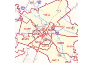
Fayette County Zip Code Map, Kentucky
The highly detailed Fayette County, Kentucky Zip Code Map shows 5 digit Zip code areas overlaid on a road map marked with red boundaries. The base map features all the geographic details including forested areas, major roads, and highways (I-75, I-64, US-25, Kentucky Highway-4, and more). The map also entails various street details with marked landmarks, government buildings, schools, Hospital Campus, Airports, and a variety of points of interest are depicted on this map. The base map depicts legend at the bottom helps identify all signs, graphics, and symbols used on the map. There is also the option of adding the title of one’s own choice to the Map
This map is available in a scale of 1:35,000 in 48 x 36 inches in landscape orientation. If you want a map with different extents, or portrait orientation, or scale, you can do that by customizing the map here. If you have any questions, we will be happy to answer over the phone (866) 525-2298 or write to us