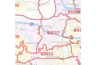
St. Charles County Zip Code Map, Missouri
The detailed St.Charles County Zip Code Map, Missouri highlights Municipal, Town, and Zip Code boundaries. The map exhibits in detail Zip code areas overlaid on a road map. The major roads and highways (I-64, I-70, US-40, Rte-79, and more) water bodies, recreational parks are easily identifiable on the map. A map legend at the bottom helps identify all signs and symbols used on the map. Infrastructures such as hospitals, industrial complexes, and other business-centric features can be easily recognized on the map. This customizable map is available in various sizes, landscape, and portrait orientation, and various premium finishes.
This map is available in a scale of 1:35,000 in 48 x 36 inches in landscape orientation. If you want a map with different extents, or portrait orientation, or scale, you can do that by customizing the map here. If you have any questions, we will be happy to answer over the phone (866) 525-2298 or write to us