Essex County Zip Code Map, New Jersey
The Essex County Zip Code Map, New Jersey has been arranged with perfection, based on the well-researched reliable data. The map clearly marks all the 5 digit Zip Code areas using red boundaries. This map shows extensive geographic details. All the major roads and highways ( I-95, I-80, I-78, U.S-22, and New Jersey Route 7 and more) are labeled with grey and Blue lines respectively. The town, municipality, and ZIP Code areas are marked on the map.
This map is available in a scale of 1:35,000 in 48 x 36 inches in landscape orientation. If you want a map with different extents, or portrait orientation, or scale, you can do that by customizing the map here. If you have any questions, we will be happy to answer over the phone (866) 525-2298 or write to us
Details on the Essex County, New Jersey Map
The map includes all the Geographical and physical details like forested areas, river, and other features. Railways, ferry routes, and high-level land use such as parks (Anderson Park, Grover Cleveland Park, and more) and recreation areas, industrial areas, postal districts, Airports (Newark Liberty International Airport and Essex County Airport), hospital campuses are mentioned at a detailed scale. Important neighborhoods, border crossings are also featured on the map.
A map legend featured at the bottom helps The customizable map is available in landscape and portrait orientation and various sizes. This high-quality Essex County, New Jersey Zip Code map is available in various premium finishes including paper, canvas, and laminated. There is also the option of adding the title of one’s own choice to the Map.
Uses of Essex County, New Jersey Zip Code Map
This high-quality map can be used in ample ways:
- For different business functions including the planning of deliveries, home services, sales territories, real estate, and more.
- The extensive road networks make this map an ideal tool for general references and planning road trips.
- Or as wall decor in their home or office.
Customization options available for the Map
We have a high-quality, customizable version of this map that can be centered around any area of your choice. Logistic and service delivery businesses can also use these maps for cropping their service delivery area maps from the base maps. Holiday home/cottage owners can create customized maps with the location of their holiday home and crop the area to order a customized map poster for their wall.
Facts and Figures of Essex County, New Jersey
- Latitudinal and longitudinal Coordinates- 40.79.N 74.25.W
- Total Area-129.6 sq miles (335.74 km2)
- Total Land Area-126.2 sq miles (326.8 km2)
- Total Water Area-3.4 sq miles (8.86 km2)
About Essex County, New Jersey and its location
Essex County is a county in the northeastern part of the U.S. State of New Jersey. Its county seat is Newark, the most populous city in the state. It is part of the New York Metropolitan Area. The County rises from generally flat in the east to the twin ridges of the Watchung Mountains in the western half, beyond which the land lowers again into the Passaic River valley. The highest elevation is found at four areas scattered between Verona, North Caldwell, and Cedar Grove, reaching 660 feet (200 m) above sea level. The lowest point is sea level, Newark Bay. Adjacent Counties surrounding Essex County, New Jersey are:
- North- Passaic County
- East- Bergen County, Hudson County
- South- Union County
- West- Morris County
Zip and Area Codes of Essex County, New Jersey
Essex County, New Jersey is associated with roughly 45 Zip Codes by the US Postal service. It ranges between 07003-07079, 07101-07199. The area codes are 973,862 ,551,908,732,848 and 201. Essex County, New Jersey covers 21 cities.
Parks and Recreation in Essex County, New Jersey
Essex County was the first County in the United States to have its own parks department, It is called the Essex County Park System.
| SKU | svd_essex_county_nj |
|---|---|
| Map Scale | 1:35k |
| Flat Size | 36 x 48 in |
-
![Clifton ZIP Code Map, New Jersey]() Clifton ZIP Code Map, New JerseyPrice from $41.99
Clifton ZIP Code Map, New JerseyPrice from $41.99 -
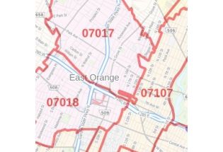
![East Orange ZIP Code Map, New Jersey]() East Orange ZIP Code Map, New JerseyPrice from $41.99
East Orange ZIP Code Map, New JerseyPrice from $41.99 -
![Newark, NJ Map]() Newark, NJ MapPrice from $32.99
Newark, NJ MapPrice from $32.99 -
![East Orange, NJ Map]() East Orange, NJ MapPrice from $24.99
East Orange, NJ MapPrice from $24.99 -
![Kearny town, NJ Map]() Kearny town, NJ MapPrice from $24.99
Kearny town, NJ MapPrice from $24.99 -
![Newark ZIP Code Map, New Jersey]() Newark ZIP Code Map, New JerseyPrice from $41.99
Newark ZIP Code Map, New JerseyPrice from $41.99