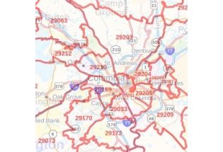
Lexington County Zip Code Map, South Carolina
This Zip Code Map of Lexington County, South Carolina has been sketched based on well-researched accurate data showing various Zip Codes in the area. It marks all 5 digit Zip Code areas using red boundaries overlaid on the road map. Significant physical attributes like, Forest Areas (Pinchot State Forest), Major water bodies (Murray Lake, Broad River, and more) recreation parks (Riverbanks Botanical Garden, Riverbanks Waterfall Junction, and Waterpark and more) are visible on the map. Transportation routes (I-26, I-20, I-77) interlinking the state of South Carolina, USA are marked on the map. Major infrastructure like colleges, airports, Police stations, industrial complexes, hospitals is also identifiable.
This map is available in a scale of 1:70,000 in 48 x 36 inches in landscape orientation. If you want a map with different extents, or portrait orientation, or scale, you can do that by customizing the map here. If you have any questions, we will be happy to answer over the phone (866) 525-2298 or write to us