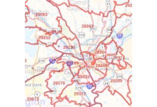
Richland County Zip Code Map, South Carolina
This Zip Code Map of Richland County, South Carolina exhibits details about Zip Code areas overlaid on a road map marked with red boundaries. Information on the map also describes Municipal, Town, and Zip Code boundaries and physical details like water bodies (Broad River, Congaree River, and Lake Murray) and forested areas (Congaree National Park, Fort Jackson, and more). Infrastructures such as hospitals, industrial complexes, airports, parks (Riverbanks Zoo and more), recreation areas, Universities, and other business-centric features can be identified on the map. The base map also features all the major roads and highways (I-26, I-20, I-77, I-126) and neighborhoods with names. A map legend at the bottom helps us identify all signs and symbols used on the map.
This map is available in a scale of 1:70,000 in 48 x 36 inches in landscape orientation. If you want a map with different extents, or portrait orientation, or scale, you can do that by customizing the map here. If you have any questions, we will be happy to answer over the phone (866) 525-2298 or write to us