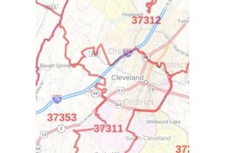
Hamilton County Zip Code Map, Tennessee
In this Hamilton County Zip Code Map, Tennessee you can find various points of interest and land use areas marked in the city. This map includes all the Zip Codes marked with red boundaries within the county. Important Geographic details like Forested areas (Chickamauga and Chattanooga National Military Park (part)), water bodies, major roads, and highways (I-24, I-75, I-124, U.S-11, US-27, SR-2, and more), railways, streets are mentioned in detailed scales. The map also shows high-level land use like parks, recreation areas( Harrison Bay State Park and more and more), Golf Clubs industrial areas, hospital campuses, airports, police stations, schools, and colleges (Chattanooga State Community College and more).
This map is available in a scale of 1:35,000 in 48 x 36 inches in landscape orientation. If you want a map with different extents, or portrait orientation, or scale, you can do that by customizing the map here. If you have any questions, we will be happy to answer over the phone (866) 525-2298 or write to us