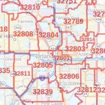
Orlando FL, Map
The detailed Orlando city map highlights Municipal, Town, and Zip code boundaries. The major roads and highways(I-4, U.S-17, U.S-92, SR-414, SR-423, SR-408), neighborhoods, lakes( Lake pineloch, Lake Nona), are easily identifiable on the map. A map legend at the bottom helps identify all signs and symbols used on the map.
Details on The Map
The Orlando City map includes many details like display highway infrastructure including interchanges, weigh stations and tolls, Full street labeling, block, and streets with names. Infrastructures such as hospitals, shopping malls, exhibition centers, industrial complexes, airports, and other business-centric features can be identified in the map.
The max print scale of the map is 1:10,000 and the Min Print scale is 1:2,000,000. The customizable map is available in landscape and portrait orientation. This Orlando, Florida map is available in various premium finishes including paper, canvas, durable plastic, and laminated.
Use of Orlando, Florida Map
Orlando is an ideal map locating and marking points of interest, roads, business service areas and city areas on a large poster. This map is ideal for the business owner who needs a local or regional road network information within a service delivery, catchment area, or a sales territory. The Product can be perfect wall decor for your home, offices, and schools. The elaborate road networks make this map an ideal tool for general references and planning trips.
About Orlando, Florida
Orlando is a city in the U.S state of Florida and the county seat of Orange County. In Central Florida, it is the center of the Orlando metropolitan area. The City is home to the University of Central Florida. In 2010, Orlando was listed as a “Gamma-“ level global city in the world Cities Study Group’s inventory. Orlando is one of the most-visited cities in the world primarily driven by tourism, major events, and convention traffic.
Geography of Orlando, Florida
The geography of Orlando consists mostly of wetlands including many lakes and swamps. The terrain is generally flat, making the land fairly low and wet. The area is dotted with hundreds of lakes, the largest of which is Lake Apopka. Central Florida’s bedrock is mostly limestone and very porous; the Orlando area is susceptible to sinkholes.
There are 115 neighborhoods within the city limits and many unincorporated communities. Orlando’s city resembles a checkerboard, with pockets of Unincorporated Orange County surrounded by city limits.
Tourism of Orlando, Florida
The two largest and most internationally renowned tourist attractions in the Orlando area include the Walt Disney World Resort, located approximately 21 miles (34 km) southwest of Downtown Orlando in Bay Lake, and the Universal Orlando Resort opened in 1990 as a major expansion of Universal Studios Florida. Major attractions are located along International Drive with one of these attractions being the Wheel at ICON Park Orlando.
The city is also one of the busiest American cities for conferences and conventions. Orange County Convention Center is the second-largest convention facility in the United States.
Zip and Area Codes of Orlando, Florida
The area codes of Orlando City are 321,407 and 689. Orlando City roughly covers 59 ZIP codes ranging from 32801-32899.
More Maps Of Florida Cities
| SKU | svd_fl_orlando_36 |
|---|---|
| Map Scale | 1:28k |
| Flat Size | 36 x 48 in |

-
![Orange County ZIP code Map (Florida)]() Orange County ZIP code Map (Florida)Price from $39.99
Orange County ZIP code Map (Florida)Price from $39.99 -
![Orlando ZIP Code Map, Florida]() Orlando ZIP Code Map, FloridaPrice from $41.99
Orlando ZIP Code Map, FloridaPrice from $41.99 -
![Altamonte Springs ZIP Code Map, Florida]() Altamonte Springs ZIP Code Map, FloridaPrice from $41.99
Altamonte Springs ZIP Code Map, FloridaPrice from $41.99 -
![Orlando, FL Zip Code Map]() Orlando, FL Zip Code MapPrice from $41.99
Orlando, FL Zip Code MapPrice from $41.99 -
![Casselberry ZIP Code Map, Florida]() Casselberry ZIP Code Map, FloridaPrice from $41.99
Casselberry ZIP Code Map, FloridaPrice from $41.99 -
![Doctor Phillips ZIP Code Map, Florida]() Doctor Phillips ZIP Code Map, FloridaPrice from $41.99
Doctor Phillips ZIP Code Map, FloridaPrice from $41.99