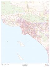
Glendale Map
This map of Glendale has been designed with accuracy based on well-researched data. The map highlights Municipal, town, and Zip code boundaries. Transportation routes ( I-5, SR-134, SR-2) interlinking the cities of California, the USA is marked neatly in the map with color-coded markings.
Major infrastructure like colleges, airports, police stations, shopping malls, industrial complexes, hospitals train stations is also identifiable. A map legend featured at the bottom helps all the signs, characters graphics, and symbols used throughout the map.
About Glendale, California
Glendale is a city in Los Angeles County, California, United States. It is located about 10 miles (16 km) north of downtown Los Angeles. Glendale lies in the southeastern end of the San Fernando Valley, bisected by the Verdugo Mountains, and is a suburb in the Los Angeles metropolitan area. The Golden State and Foothill freeways run through the City. The Zip code of the City ranges from 91201-91226 and the area code is 747 and 818.
Cities and Towns Bordering Glendale, California
- Northwest- Sun Valley and Tujunga
- Northeast- La Canada Flintridge
- East - Eagle Rock and Pasadena
- South - Atwater Village
- West- Burbank and Griffith Park
More maps of California Cities
| SKU | svd_ca_glendale_24 |
|---|---|
| Map Scale | 1:11,000 |
| Flat Size | 24 x 36 in |


-
![Los Angeles County Zip Code Map, California]() Los Angeles County Zip Code Map, CaliforniaPrice from $42.99
Los Angeles County Zip Code Map, CaliforniaPrice from $42.99 -
![Pasadena ZIP Code Map, California]() Pasadena ZIP Code Map, CaliforniaPrice from $41.99
Pasadena ZIP Code Map, CaliforniaPrice from $41.99 -
![Burbank ZIP Code Map, California]() Burbank ZIP Code Map, CaliforniaPrice from $41.99
Burbank ZIP Code Map, CaliforniaPrice from $41.99 -
![Glendale ZIP Code Map, California]() Glendale ZIP Code Map, CaliforniaPrice from $41.99
Glendale ZIP Code Map, CaliforniaPrice from $41.99 -
![Eagle Rock ZIP Code Map, California]() Eagle Rock ZIP Code Map, CaliforniaPrice from $41.99
Eagle Rock ZIP Code Map, CaliforniaPrice from $41.99 -
![Pasadena Map]() Pasadena MapPrice from $24.99
Pasadena MapPrice from $24.99