Thousand Oaks Map
This map of Thousand Oaks has been designed with accuracy based on well-researched data. The map highlights Municipal, town, and Zip code boundaries. Transportation routes (SR-101, SR-23) interlinking the cities of California, the USA is marked neatly in the map with color-coded markings.
Major infrastructure like colleges, airports, police stations, shopping malls, industrial complexes, hospitals train stations is also identifiable. A map legend featured at the bottom helps all the signs, characters graphics, and symbols used throughout the map.
About Thousand Oaks, California
Thousand Oaks is a city in Ventura County, California, United States. It is located in the northwestern part of Greater Los Angeles, approximately about 40 miles (64 km) north of downtown Los Angeles. It is named after the many Oak trees present in the area, and the City seal is adorned with an oak.
The City forms the central populated core of Conejo Valley. The Los Angeles County-Ventura County line crosses at the City’s eastern border Westlake Village. The ZIP code of the City ranges from 91359, 91320, 91360-91362 and the area codes are 805/820.
More maps of California Cities
| SKU | svd_ca_thousand_oaks_24 |
|---|---|
| Map Scale | 1:13,000 |
| Flat Size | 24 x 36 in |


-
![Simi Valley ZIP Code Map, California]() Simi Valley ZIP Code Map, CaliforniaPrice from $41.99
Simi Valley ZIP Code Map, CaliforniaPrice from $41.99 -
![Thousand Oaks ZIP Code Map, California]() Thousand Oaks ZIP Code Map, CaliforniaPrice from $41.99
Thousand Oaks ZIP Code Map, CaliforniaPrice from $41.99 -
![Agoura Hills Zip Code Map, California]() Agoura Hills Zip Code Map, CaliforniaPrice from $41.99
Agoura Hills Zip Code Map, CaliforniaPrice from $41.99 -
![Calabasas ZIP Code Map, California]() Calabasas ZIP Code Map, CaliforniaPrice from $41.99
Calabasas ZIP Code Map, CaliforniaPrice from $41.99 -
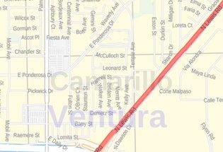
![Camarillo ZIP Code Map, California]() Camarillo ZIP Code Map, CaliforniaPrice from $41.99
Camarillo ZIP Code Map, CaliforniaPrice from $41.99 -
![Simi Valley Map]() Simi Valley MapPrice from $24.99
Simi Valley MapPrice from $24.99