Beaumont Map
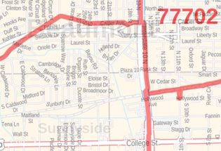
This map of Beaumont has been designed with accuracy based on well-researched data. Significant physical attributes like, Major Rivers(Neches River), lakes(LakeBayou), recreation parks, are clearly visible on the map. The map highlights Municipal, town, and Zip code boundaries.
Transportation routes ( I-10, U.S-287, U.S-96, U.S-90) interlinking the cities of Texas, the USA is marked neatly in the map with color-coded markings. Major infrastructure like colleges, airports, police stations, shopping malls, industrial complexes, hospitals train stations is also identifiable.
About Beaumont, Texas
Beaumont is a city in and the county seat of Jefferson County, Texas, in the United States, within the Beaumont-Port Arthur Metropolitan Statistical Area. The City is located in Southeast Texas on the Neches River about 85 miles (137 km) east of Houston and just south of the dense pine forests of East Texas and to the north by Pine Island Bayou. Beaumont is about 30 miles (48 km) inland from the Gulf of Mexico.
The Zip codes of the City range from 77701-77710,77713,77720,77725,77726 and the area code is 409.
More maps of Texas Cities
| SKU | svd_tx_beaumont_36 |
|---|---|
| Map Scale | 1:25,000 |
| Flat Size | 24 x 36 in |


-
![Beaumont Zip Code Map, Texas]() Beaumont Zip Code Map, TexasPrice from $41.99
Beaumont Zip Code Map, TexasPrice from $41.99 -
![Baytown ZIP Code Map, Texas]() Baytown ZIP Code Map, TexasPrice from $41.99
Baytown ZIP Code Map, TexasPrice from $41.99 -
![China Zip Code Map, Texas]() China Zip Code Map, TexasPrice from $41.99
China Zip Code Map, TexasPrice from $41.99 -
![Cleveland Zip Code Map, Texas]() Cleveland Zip Code Map, TexasPrice from $41.99
Cleveland Zip Code Map, TexasPrice from $41.99 -
![Lake Charles, LA Map]() Lake Charles, LA MapPrice from $24.99
Lake Charles, LA MapPrice from $24.99 -
![Sulphur, LA Map]() Sulphur, LA MapPrice from $24.99
Sulphur, LA MapPrice from $24.99