Madera County Zip Code Map, California
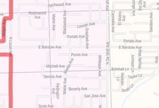
This Zip Code Map of Madera County has been built with precision based on well-researched data. The map marks all the 5 digit Zip Code areas using red boundaries. Significant physical attributes like water bodies, Forested areas, recreation parks are also clearly visible on the map. The map also highlights Municipal, Town, and Zip Code boundaries.
This map is available in a scale of 1:30,000 in 48 x 36 inches in landscape orientation. If you want a map with different extents, or landscape orientation, or scale, you can do that by customizing the map here. If you have any questions, we will be happy to answer over the phone (866) 525-2298 or write to us
Transportation routes (SR-49, SR-41, and more) interlinking the counties of the state of California, USA are marked in the map with color-coded markings. Major infrastructure like airports, police stations, postal districts, industrial complexes, hospitals, and border crossings are also identifiable.
About Madera County, California
Madera County is a county located at the geographic center of the U.S state of California. The county seat is Madera. Madera County comprises the Madera, California Metropolitan Statistical Area, which is also included in the Fresno-Madera, California combined Statistical Area. Madera County is located in the eastern San Joaquin Valley and the central Sierra Nevada. The southeasternmost part of Yosemite National Park is located in the County’s northeast.
More maps of California
| SKU | svd_madera_county_ca |
|---|---|
| Map Scale | 1:30k |
| Flat Size | 36 x 48 in |
-
![Fresno, California Inner Metro - Landscape Map]() Fresno, California Inner Metro - Landscape MapPrice from $39.99
Fresno, California Inner Metro - Landscape MapPrice from $39.99 -
![Fresno, California Inner Metro - Portrait Map]() Fresno, California Inner Metro - Portrait MapPrice from $39.99
Fresno, California Inner Metro - Portrait MapPrice from $39.99 -
![Clovis ZIP Code Map, California]() Clovis ZIP Code Map, CaliforniaPrice from $41.99
Clovis ZIP Code Map, CaliforniaPrice from $41.99 -
![Fresno Map]() Fresno MapPrice from $32.99
Fresno MapPrice from $32.99 -
![Merced County Zip Code Map, California]() Merced County Zip Code Map, CaliforniaPrice from $32.99
Merced County Zip Code Map, CaliforniaPrice from $32.99 -
![Fresno County ZIP code Map (California)]() Fresno County ZIP code Map (California)Price from $39.99
Fresno County ZIP code Map (California)Price from $39.99