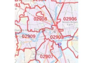
Providence County Zip Code Map, Rhode Island
This is a detailed Providence County Zip Code Map, Rhode Island showing various ZIP codes in the area. It marks all 5 digit Zip code areas using red boundaries overlaid on the road map. City, township and municipality areas are also demarcated with distinct colors.
This map is available in a scale of 1:35,000 in 48 x 36 inches in landscape orientation. If you want a map with different extents, or portrait orientation, or scale, you can do that by customizing the map here. If you have any questions, we will be happy to answer over the phone (866) 525-2298 or write to us
Details on the Providence County Zip Code Map, Rhode Island
The base map features all the major roads and highways (I-95, I-195, I-295, U.S-1, U.S-6, Route-5, Route-10, Route-7, and more) along with neighborhood names. Significant physical attributes like, Forest Areas (Blackstone River Valley National Historical Park (part), Roger Williams National Memorial), Major water bodies (Blackstone River, Woonasquatucket River, and more) are visible on the map. Airport, Railways, ferry routes, and high-level land use like parks and recreation areas (Roger Williams Park Zoo, Waterplace Park), industrial areas, postal districts and hospital campuses, are mentioned at a detailed scale. A map legend featured at the bottom helps identify all signs and symbols used on the map. There is also an option of adding the title of one’s own choice in the Map.
Uses of Providence County, Rhode Island Zip Code Map
This map can be used in multiple ways for various business functions including planning delivery, retail sitting, sales region planning, and real estate. This map is also used for direct mail marketing via some companies. The elaborate road networks make this map an ideal tool for general references and planning long-distance trips.
Customization options available for Providence County, Rhode Island Zip code Map
We have a high-quality, customizable version of this map that can be centered around any area of your choice. The zoom buttons and drag arrows on the map will help you define the print area. Logistic and service delivery businesses can also use these maps for cropping their service delivery area maps from the base maps. Holiday home/cottage owners can create customized maps with the location of their holiday home and crop the area to order a customized map poster for their wall. The map can be customized in both portrait and landscape orientation.
Facts and Figures of Providence County, Rhode Island
- Latitudinal and longitudinal Coordinates-41.51’10” N 71.27’22” W
- Total Area- 436 sq miles (1,130 km2)
- Total Land Area-410 sq miles (1,100 km2)
- Total Water Area-26 sq miles (70 km2)
About Providence County, Rhode Island
Providence County is the most populous county in the U.S state of Rhode Island. Providence County contains the city of Providence, the state capital of Rhode and the county’s and state’s most populous city. Providence County is included in the Providence-Warwick, RI-MA Metropolitan Statistical Area, which in turn constitutes a portion of the greater Boston-Worcester-Providence, MA-RI-NH-CT Combined Statistical Area. The highest natural point in the county and the state of Rhode Island is Jerimoth Hill at 812 feet (247 m).
Adjacent counties near Providence County, Rhode Island
- West- Windham County, Connecticut
- Southeast- Bristol County
- South- Kent County
- North- Clay County, Missouri
- Northeast- Norfolk County, Massachusetts
- East- Bristol County, Massachusetts
- Northwest- Worcester County, Massachusetts
Zip Codes of Providence County, Rhode Island
Providence County, Rhode Island roughly covers 46 ZIP Codes. These range between 02802-02896, 02901-02940. USPS introduced these codes in the country in 1963 with an aim of an effective mail delivery system. The area code of the county is 401 Providence County, Rhode Island covers 31 Cities.
| SKU | svd_providence_county_ri |
|---|---|
| Map Scale | 1:35K |
| Flat Size | 36 x 48 in |
-
![Cranston ZIP Code Map, Rhode Island]() Cranston ZIP Code Map, Rhode IslandPrice from $41.99
Cranston ZIP Code Map, Rhode IslandPrice from $41.99 -
![Providence, RI Map]() Providence, RI MapPrice from $32.99
Providence, RI MapPrice from $32.99 -
![Cranston, RI Map]() Cranston, RI MapPrice from $24.99
Cranston, RI MapPrice from $24.99 -
![Central Falls, RI Map]() Central Falls, RI MapPrice from $24.99
Central Falls, RI MapPrice from $24.99 -
![Valley Falls, RI Map]() Valley Falls, RI MapPrice from $24.99
Valley Falls, RI MapPrice from $24.99 -
![Providence ZIP Code Map, Rhode Island]() Providence ZIP Code Map, Rhode IslandPrice from $41.99
Providence ZIP Code Map, Rhode IslandPrice from $41.99