Lake Como Map
Details
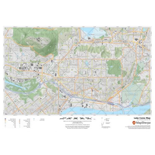
Lake Como Map
This detailed Lake of Como map marks every political and physical feature of the lake and its surrounding regions. Major landmarks like roads, rails, trails, parks, forests, and mountain ranges are easily identifiable on the map. Relief shading and elevation contour lines are also used throughout the map to depict the height above the sea level.
You can use this high-quality map for wall display in office spaces, educational institutions, and homes. It is also ideal to take along on your next trip. You can even gift this fascinating map to your loved ones who love traveling and exploring new places. This versatile map is available to buy in a variety of finishing materials including paper, lamination, and matte plastic.
How to customize this Lake Como map?
We also offer an option to customize this map around any location of your choice. You can zoom in the map and center it on any nearby cottage, resort or any other part of the lake. You can make all the necessary adjustments, crop the area, add any title to the map, and select from a range of orientation, sizes and paper finishes before ordering.
Start editing the custom map of Lake Como here.
Where is Lake Como?
The northern branch of Lake Como starts at the town of Colico and the towns of Como and Lecco sit at the ends of the southwestern and southeastern branches respectively. Many other small towns like Bellagio, Menaggio, and Lierna lie at the intersection of the three branches of the lake. There is a triangular boat service that operates between them. The lake is fed by the Adda River, which enters the lake near Colico and flows out at Lecco.
It is a popular tourist destination known for its landscapes, wildlife, and spas. Outdoor recreational activities like sailing, windsurfing, and kitesurfing are popular here.
Bathymetry of the Lake
The surface area of Lake Como is 146 square km (56 sq mi), making it the third-largest lake in Italy. It is also the fifth deepest lake in Europe and the deepest outside Norway with an average depth of 154 m (505 ft) and a maximum of 425 m (1,394 ft).
Its maximum length is 46 km (29 mi) and width is 4.5 km (2.8 mi). The shoreline of the lake measures 160 km (99 mi).
More Information
| SKU | 9ec2ccde4ea71cd83900cdedf628db72-Como-L-BC |
|---|---|
| Map Specification | Max Print Scale - 1:15,000 Min Print Scale - 1:2,000,000 Optimal Print Scale - All |
| Publisher Name | MapSherpa |
Reviews
{{title}}
{{detail}}