Germany - Atlas of the World, 10th Edition
Details
Flag -
Country full name - Federal Republic of Germany
Important National Days - German Unity Day: 3rd October
Capital City - Berlin
Major Cities - Berlin, Hamburg, Munich, Cologne, Frankfurt, Stuttgart, Düsseldorf, Dortmund
Continent - Europe
Currency - Euro
Primary Languages -German, Frisian
Time-Zone - (GMT+1)
ISO CODE - DEU
Country Code - 49
Area Covered - 357,386 sq km
Neighbouring Countries - France, Austria, Switzerland, Poland, Netherlands
National Mapping Agency - Federal Agency for Cartography and Geodesy
Did you know? - Berlin, the largest city is the capital of Germany. The country is also a member of the European Union. It has the largest economy in Europe.
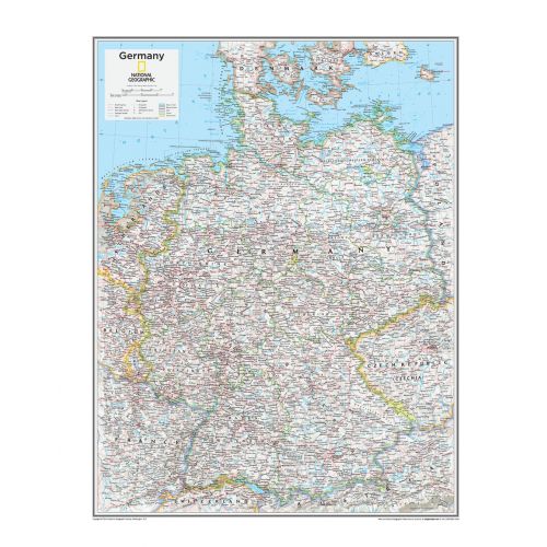
Germany Map
This is a highly detailed National Geographic map that features all the key political details. Country names along with capitals are labelled clearly in legible texts, provincial boundaries, different regions are denoted in the lighter shaded background. Map features other incredible cartographic details that are the trademark of National Geographic quality. This map of Germany from the Atlas of the World accurately shows locations of provincial boundaries, cities and towns, major highways and roads, rivers and waterways, and other geographic features.
Germany is a federal parliamentary republic with great power and a strong economy. It has the world's fourth - largest economy by nominal GDP, and the fifth-largest by PPP. It also earns a social market economy and is also known as the world's third largest exporter of goods, and has the largest national economy in Europe which is also the world's fourth-largest by nominal GDP.
More Information
| SKU | ngmaps-POD10th067-1 |
|---|---|
| Flat Size | 22 x 28 in |
| Publication Date | 25-02-2015 |
| Publisher Name | National Geographic |
Reviews
{{title}}
{{detail}}