Plantation Map
Details
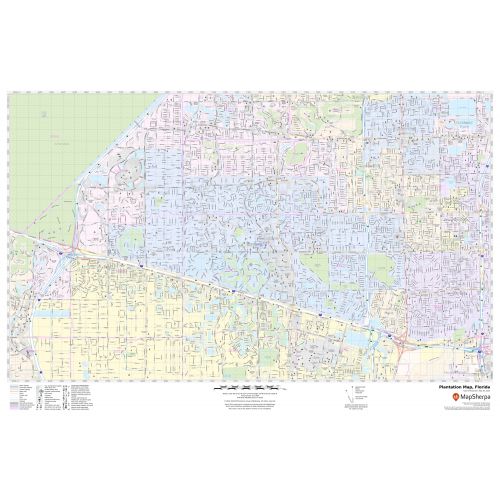
The Detailed Plantation City map depicts street details with marked landmarks, shopping malls(Westfield Broward Mall)government buildings, schools, churches, University, Golf and Country clubs, highways (I-595, U.S-441, SR-817), and more. The map also highlights Municipal, Town, and Zip code boundaries.
The map also depicts hospital campuses, postal districts, streets and neighborhoods, industrial areas, and recreation areas, and much more. A map legend featured at the bottom helps all the signs, characters graphics, and symbols used throughout the map.
About Plantation, Florida
The plantation is a city located in central Broward County, Florida, United States. It is a principal city of the Miami metropolitan area. The City’s name comes from the previous part-owner of the land, the Everglades plantation Company, and their attempts to establish a rich plantation in the area.
The ZIP codes of the City are 33311,33313,33317,33322-33325,33388 and the area code are 754 and 954
Cities near the Plantation, Florida
- South- Davie
- Northeast- Lauderhill
- North-Sunrise
- East- Fort Lauderdale
- West- Sunrise
More Maps Of Florida Cities
More Information
| SKU | svd_fl_plantation_24 |
|---|---|
| Map Scale | 1:16,000 |
| Flat Size | 24 x 36 in |
Reviews
{{title}}
{{detail}}