Midland Map
Details
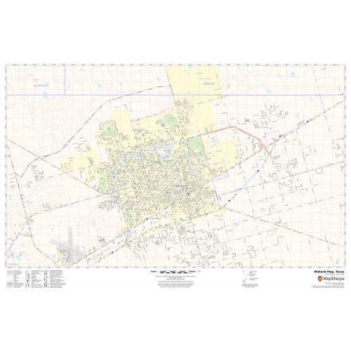
In this highly detailed Midland Map, you can find various points of interest and land use areas marked in the city. The map highlights Municipal, town, and ZIP code boundaries. The map also shows the latest changes in your area. The map includes extensive Geographic details like River, lakes, interstate (I-20) (SR-158), and state highways (SH-349), streets with street names, at detailed scales.
The map also depicts a high-level land use like parks, museums, recreation areas, industrial areas, and hospital campuses. Major infrastructure like airports, police stations, shopping malls, industrial complexes, train stations is also identifiable.
About Midland, Texas
Midland is a city in and the county seat of Midland County, Texas, the United States on the Southern Plains of the state’s western area. A small portion of the City extends into Martin County. Midland was founded as the midway point between Fort Worth and El Paso in the Texas and Pacific Railroad. Midland is located in the Permian Basin in the plains of West Texas. It is the principal city of the Midland, Texas metropolitan statistical area.
Facts and Figures of Midland, Texas
- Latitudinal and longitudinal Coordinates-32.0’N 102.6’W
- Elevation - 2,782 Ft (848 m)
- Zip Code - 79701-12
- Area Code - 432
- Total Area - 71.5 sq miles(185.2 km2)
More maps of Texas Cities
More Information
| SKU | svd_tx_midland_36 |
|---|---|
| Map Scale | 1:26,000 |
| Flat Size | 24 x 36 in |
Reviews
{{title}}
{{detail}}