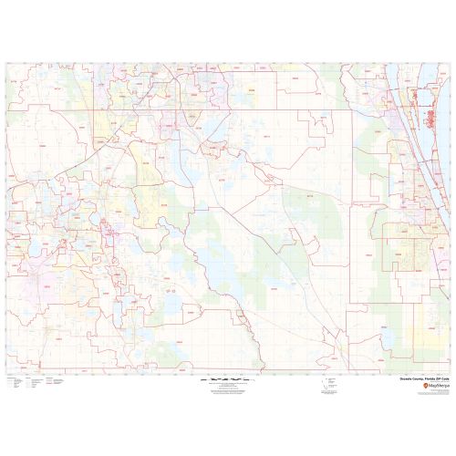
Osceola County ZIP Code Map, Florida
The highly detailed Osceola County, Florida Zip Code Map shows 5 digit Zip code areas overlaid on a road map marked with red boundaries. The base map features including all the geographic details. Interstate highways (I-4, US-441 and more) The map also entails various street details with marked landmarks, government buildings, schools, Hospital Campus, Airport (Kissimmee Gateway Airport), major roads, and a variety of points of interest are depicted on this map. The base map depicts legend at the bottom helps identify all signs, graphics, and symbols used on the map. There is also an option of adding the title of one’s own choice in the Map.
Details
About Osceola County, Florida
Osceola County is a county located in the central portion of the U.S. State of Florida. The county seat is Kissimmee. Osceola County is included in the Orlando-Kissimmee-Sanford, Florida Metropolitan Statistical Area.
Adjacent Counties bordering Osceola County, Florida
- South- Highlands County
- North- Orange County
- SouthEast- Okeechobee County
- East- Indian River County
- Northeast - Brevard County
- West- Polk County
- Northwest- Lake County
More Information
| SKU | svd_osceola_county_fl |
|---|---|
| Map Scale | 1:84,000 |
| Flat Size | 36 x 48 in |
Reviews
{{title}}
{{detail}}