Cape York Supermap
Details
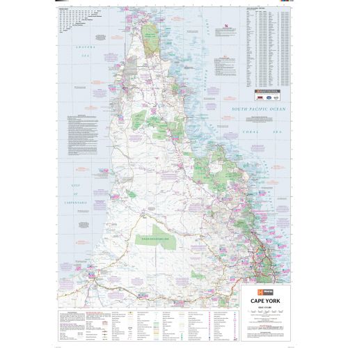
Cape York Australia map
This extra-large and detailed Cape York Australia map mark major roads, 4WD tracks, parks & reserves, hospitals, airports, camping areas, and other points of interest. A distance chart, town and localities index, and a map legend is also featured on the map. National parks and water bodies are highlighted in green and blue colors throughout the map.
You can buy this map in a selection of finishing materials ranging from paper, matte plastic, and laminated.
Where is Cape York?
The largest unspoiled wilderness in Northern Australia, the Cape York Peninsula is a remote peninsula located in Queensland, Australia. It is bordered by the Gulf of Carpentaria by the west coast and the Coral Sea by the east coast.
The land area is mostly flat and more than half of it is used for grazing cattle. It is recognized and preserved for their global environmental significance due to its undisturbed eucalyptus wooded savannahs, tropical rainforests and other types of habitat.
Surrounding Water Bodies
The surrounding water bodies to the Cape York Peninsula, also visible on the map are:
- The Great Barrier Reef
- South Pacific Ocean
- The Coral Sea
- Gulf of Carpentaria
- Arafura Sea
More Information
| SKU | hema-ZEOCAP01F-1 |
|---|---|
| Map Scale | 1:715,000 |
| Flat Size | 38.75 x 55.25 in |
| Publication Date | 2014-08-02 |
| Publisher Name | Hema Maps |
Reviews
{{title}}
{{detail}}