Zimbabwe
Details
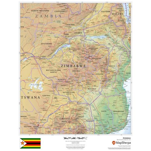
Zimbabwe Country Map
Zimbabwe map shows detailed political and physical features of the country. It uses relief shading and different color hues to depict the height above sea level. You can view all major cities including the capital city, Harare, and other surrounding places on the map. A small flag of the country is also featured at the bottom of the map.
You can buy this detailed map of Zimbabwe in a selection of finishes that include paper, matte plastic, and laminate.
Where is Zimbabwe?
Zimbabwe is a landlocked country in South Africa that lies between the Zambezi and Limpopo Rivers. It lies between latitudes 15° and 23°S, and longitudes 25° and 34°E. The northwest corner of the country is roughly 150 meters from Namibia, nearly forming a four-nation quadripoint.
Major Cities in Zimbabwe
Below is a list of the largest cities in the country by population. You can buy maps of all these cities by clicking on their respective names. Also, all these city maps are customizable, i.e you can center them around your preferred location and order them in various sizes and finishes.
Zimbabwe Neighboring Places
Zimbabwe shares its border with a number of other countries. You can find maps of all these places separately by clicking on their name below:
More Information
| SKU | dmsg-rel-zimbabwe-1 |
|---|---|
| Map Scale | 1:3,000,000 |
| Flat Size | 17 x 22 in |
| Publication Date | 2018 |
| Publisher Name | MapSherpa |
Reviews
{{title}}
{{detail}}