Fort Collins Map
Details on the map
The rich regional map includes display highway infrastructure including interchanges, weigh stations and tolls. Full street labeling, block numbers, and streets with names. Infrastructures such as hospitals, shopping malls, exhibition centers, industrial complexes, airports, and other business-centric features can be identified in the map.
The max print scale of the map is 1:10,000 and the Min Print scale is 1:2,000,000. The customizable map is available in 36x48 inches and landscape and portrait orientation. This high-quality Fort Collins, Colorado map is available in various premium finishes including paper, canvas, and laminated.
Use of Fort Collins, Colorado Map
Fort Collins Map is an ideal map locating and marking points of interest, roads, business service areas and city areas on a large poster. The MapSherpa product is ideal for the business owner who needs a local or regional road network information within a service delivery, catchment area or a sales territory. The map can be perfect wall decor for your home, offices, and schools. The elaborate road networks make this map an ideal tool for general references and planning long-distance trips.
Facts and Figures of Fort Collins, Colorado
- Latitudinal longitudinal Coordinates-N 105.03’53” W
- Elevation-5003 ft (1,525)
- Total Area-57.05 square miles (147.77km2)
- Total land area-55.82square miles (144.58 km2)
- Total water area-1.23 square miles (3.20km2)
- Economy- Fort Collins’ economy has a mix of manufacturing and service-related business.
Information about Fort Collins, Colorado
Fort Collins is a municipality in northern Colorado, which serves as the seat of Larimer County. The city is situated at the base of the Rocky Mountain foothills on the Cache La Poudre River along with the Colorado Front Range. Spring Creek runs through Fort Collins. Fort Collins is located 56miles (90 Km)north of Colorado State Capitol in Denver and 45 miles (72km) south of Cheyenne, Wyoming.
Fort Collins is a mid-size college city, home to Colorado State University and Front Range Community College’s Larimer Campus. Geographic landmarks include Horsetooth Reservoir and Horsetooth Mountain-so named because of tooth-shaped granite rock that dominates the City’s western skyline.
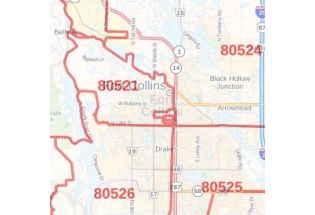
ZIP Codes of Fort Collins, Colorado
The area code is 970. Fort Collins roughly covers 9 Zip codes. It ranges from 80521-80528, 80553.
Neighborhoods of Fort Collins, Colorado
The most popular neighborhoods in Fort Collins are:
- Old Town: Located in the heart of the City, most of the Fort Collins tourist attractions are found in Old Town, including Old Town Square, the Downtown Artery, and the Museum of Art Fort Collin.
- North Fort Collins: This area offers a respite from busy downtown areas, and is situated near the Fort Collins Country Club.
- Old Prospect: This small, in-demand neighborhood comes highly recommended by residents and visitors alike because of its beauty and easy access to both the conveniences of the City and natural areas.
- Fossil Creek- A dynamic and growing neighborhood is a great option due to its high-quality schools and Verdant outdoor space.
- Mountain view: This neighborhood is located in north-central collins off of North Taft Hill Road, is one of the highest appreciating neighborhoods.
More Maps of Fort Collins
| SKU | svd_co_fort_collins_36 |
|---|---|
| Map Scale | 1:27k |
| Flat Size | 36 x 48 in |


-
![Greeley ZIP Code Map, Colorado]() Greeley ZIP Code Map, ColoradoPrice from $41.99
Greeley ZIP Code Map, ColoradoPrice from $41.99 -
![Fort Collins ZIP Code Map, Colorado]() Fort Collins ZIP Code Map, ColoradoPrice from $41.99
Fort Collins ZIP Code Map, ColoradoPrice from $41.99 -
![Greeley Map]() Greeley MapPrice from $24.99
Greeley MapPrice from $24.99 -
![Loveland Map]() Loveland MapPrice from $24.99
Loveland MapPrice from $24.99 -
![Windsor Map]() Windsor MapPrice from $24.99
Windsor MapPrice from $24.99 -
![Johnstown Map]() Johnstown MapPrice from $24.99
Johnstown MapPrice from $24.99