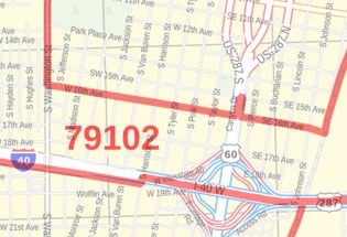
Amarillo Map
This map of Amarillo has been designed with accuracy based on well-researched data. Significant physical attributes like, Major water bodies, recreation parks, resorts are clearly visible on the map. The map highlights Municipal, town, and ZIP code boundaries.
Transportation routes (I-27, I-40, U.S-60, U.S-87, U.S-287) interlinking the cities of Texas, the USA is marked neatly in the map with color-coded markings. Major infrastructure like colleges, airports, police stations, shopping malls, industrial complexes, hospitals, train stations is also identifiable.
About Amarillo, Texas
Amarillo is the largest city located in the middle of Texas Panhandle and the seat of Potter County. A portion of the city extends into Randall Country. The City is a part of the Amarillo metropolitan area. The city was once the self-proclaimed ”Helium Capital of the world” for having one of the country's most productive fields.
It is situated in the grasslands of Northern Texas and is surrounded by dense Prairie. Amarillo sits closer in proximity to Oklahoma, New Mexico, and Colorado state capitals. The ZIP code of the City ranges from 79101-79189 and the area code is 806.
More maps of Texas Cities
| SKU | svd_tx_amarillo_36 |
|---|---|
| Map Scale | 1:34,000 |
| Flat Size | 24 x 36 in |


-
![Lubbock Zip Code Map, Texas]() Lubbock Zip Code Map, TexasPrice from $41.99
Lubbock Zip Code Map, TexasPrice from $41.99 -
![Amarillo ZIP Code Map, Texas]() Amarillo ZIP Code Map, TexasPrice from $41.99
Amarillo ZIP Code Map, TexasPrice from $41.99 -
![Clinton ZIP Code Map, Oklahoma]() Clinton ZIP Code Map, OklahomaPrice from $41.99
Clinton ZIP Code Map, OklahomaPrice from $41.99 -
![Clovis ZIP Code Map, New Mexico]() Clovis ZIP Code Map, New MexicoPrice from $41.99
Clovis ZIP Code Map, New MexicoPrice from $41.99 -
![Lubbock Map]() Lubbock MapPrice from $24.99
Lubbock MapPrice from $24.99 -
![Clovis, NM Map]() Clovis, NM MapPrice from $24.99
Clovis, NM MapPrice from $24.99