Daytona Beach FL, Map
Details
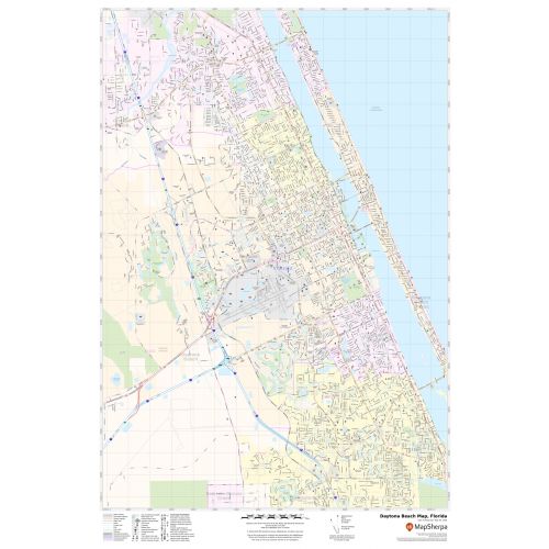
This map of Daytona Beach City has been composed with rigour based on well-researched data. Significant physical attributes like beaches, River (Halifax River) recreation parks, are clearly visible on the map. Transportation routes (I-95, I-4, SR-A1A,US-92) interlinking the cities of Florida, the USA is marked in the map with color-coded markings. Main infrastructures in the city like colleges, airports(Daytona Beach International Airport (DAB), police stations, shopping malls, industrial complexes, hospital train stations are also identifiable.
About Daytona Beach, Florida
Daytona Beach is a city in Volusia County, Florida, United States. It is a principal city of the Deltona-Daytona-Ormond Beach metropolitan area. Daytona Beach is also a principal city of the Fun Coast region of Florida. The city is historically known for its beaches and has over 23 miles (37 km) of white sandy beaches. Cars can be driven on some of the beaches during daylight hours.
Cities Bordering Daytona Beach, Florida
- North- Holy Hill, Ormond Beach
- Northeast- Orlando (51 miles)
- Northwest-Miami
- South-South Daytona, Port Orange
- Southeast-Jacksonville (265 miles)
More Maps Of Florida Cities
More Information
| SKU | svd_fl_daytona_beach_24 |
|---|---|
| Map Scale | 1:28k |
| Flat Size | 24 x 36 in |
Reviews
{{title}}
{{detail}}