Port Orange FL, Map
Details
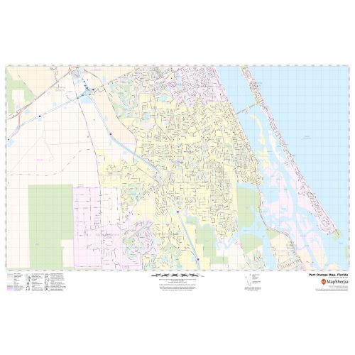
This map of Port Orange city, Florida exhibits street details with marked landmarks, government buildings, schools (Spruce Creek High School) , Colleges (Palmer College of Chiropractic),churches,main routes, highways (I-95) (U.S-92, US-1)and much more.
Information on the map also describes Municipal, Town, and Zip code boundaries. Infrastructures such as hospitals, shopping malls, exhibition centers, industrial complexes, airports, parks, recreation areas and other business-centric features (Thompson Pump and Manufacturing) can be identified in the map.
About Port Orange, Florida
Port Orange is a city in Volusia County, Florida, United States. The city is part of the Deltona-Daytona Beach-Ormond metropolitan area. Port Orange is a principal city in the Fun Coast region of the state of Florida. Education, health care and government are the area’s largest employment sectors in the city.
Facts and Figures of Port Orange, Florida
- Latitudinal and longitudinal Coordinates- 29.7’8” N 81.0’10” W
- Elevation-3 ft (0.9 m)
- Zip Code-32123,32127-32129
- Area Code-386
- Total Area-28.81 sq miles(74.61 km2)
More Maps Of Florida Cities
More Information
| SKU | svd_fl_port_orange_24 |
|---|---|
| Map Scale | 1:15k |
| Flat Size | 24 x 36 in |
Reviews
{{title}}
{{detail}}