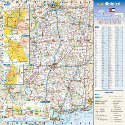
Map of Mississippi
This reference map of the Mississippi presents an overview of the urban space. The state gets its name from the Mississippi River which flows along the western side of the state. All primary and secondary cities are named and placed accurately in their true location.
The state capital Jackson is captioned in bold and easily identifiable. The elaborate road network interlinking the entire state is depicted with numbers and color-coded thread margins. It also highlights the placement of three major settlements which include the Biloxi/Gulfport metropolitan area, Vicksburg and Hattiesburg with box frames.
Details
Details on the Map
The Mississippi Map depicts the physical and political layout of the state with rich imagery and high-detail cartography. The map shows state demarcations along with placements of primary cities, secondary cities, airports, national parks, state parks, and recreational areas.
The detailed city layout of these settlements are projected in separate insets for easy understanding. Boundaries with other states are demarcated with different color shades and outlines. Points of interest, thoroughfares, freeway tollways, interchanges, and airports are marked prominently for quick reference.
This visual organizer also provides detailed information on the topographical layout of the state. The Gulf coastal plains cover most of the state with low plains and low hills. The highest summit of the state Woodall Mountains are captioned and can be placed with ease.
The Mississippi River, Big Black River, The Pearl River and the largest lake Sardis are marked notably. Other terrain features include lakes, plains, forest regions, national parks, state parks, and protected areas.
An elaborate key table simplifies symbolic data like national highways, state highways, important settlements, airports, national parks, state park, etc.
A tabular index on cities/towns and counties and a driving distance chart based on accurate information and map data makes this map perfect for general reference.
National and state highways are specifically numbered and can be identified in a glance. Separate frames highlight an elaborate know-how of major settlements which includes the city layout of Jackson, the state capital, the Biloxi/Gulfport metropolitan area, and major cities of Vicksburg and Hattiesburg. Physical attributes like mountain peaks, rivers, lakes and plains can also be located with ease.
The map is also furnished with a city with a detailed index of city /town, a county index and a driving distance chart which helps estimate the distance between two destinations. Other interesting features of the map include a miniature map of the US indicating the placement of Mississippi and a digitized flag of the State.
Location on the map
Mississippi lies in the southeastern region of the US. Tennessee borders the state to the north and Alabama borders the state to the east. Louisiana and Arkansas borders the state from the southwest and northwest respectively. The Gulf of Mexico can be placed in the south and Mississippi river form the western boundary of the state.Map Size and Map Prints
This Map of Mississippi can be ordered in a 16.75x 16.75 inch dimension. The multiple finishes available are:- paper in high-quality stock,
- laminates in a glossy finish,
- matte Plastic in Non-Glossy finish,
- matte Plastic mounted on PVC banner hanger and Canvas.
Region Location on Map of Mississippi
According to the USCB the State of Mississippi is located in the southern part of the US and falls under the east south-central region in Division 6. The other States under this division are Alabama, Kentucky, and Tennessee.Counties in Mississippi
Mississippi is divided into 82 counties. The largest county both by population and area is Hinds.Time Zone of Mississippi
Mississippi falls under the Central time zone and observes the Central Standard Time (CST) which is 6 hours behind Greenwich Mean Time.Zip Code of Mississippi
The Range of Zip codes in the state of Mississippi is from 38601- 39776. The Capital City of Jackson has zip code range from 39201-39207, 39209-39217, Biloxi: 39530-39535, Gulfport:39501-39507.
Major cities in Mississippi
The Greater Jackson Metropolitan area comprises the major population of the state and includes five counties: Copiah, Hinds, Madison, Rankin, and Simpson. Hundreds of cities and towns are captioned and can be placed throughout the extent of the map. The frame draws attention to the placement of the state capital, Biloxi/ Gulfport metropolitan area, Hattiesburg and Vicksburg with bright box highlighter.
The detailed layout of these settlements are also elaborated separately in insets for easy understanding. Other urban markings include military areas, state, and interstate highways, major roads, recreational areas, points of interest and airports. A tabular index of cities/towns and counties along with a distance marker help locate all places of importance on the map effortlessly.
Biloxi/ Gulfport Metropolitan Inset
The Biloxi/Gulfport metropolitan area is located in the Gulf Coast region of Mississippi and includes Hancock County, Harrison County, and Stone County. Gulfport and Biloxi are the two principal cities in this area. Gulfport is also the second-largest city of the state and is the seat of Harrison County, shared with Biloxi. Biloxi is the third-largest city in the state.
Other major cities that can be located in the inset include Pascagoula, Gautier, Moss Point, and Ocean Spring.
Specifics like recreation areas, landmarks locations, and points of interest can be found without an effort on the frame. The street system is numbered for easy recognition. interstate highways, national highways, state highways, other primary roads, secondary roads, freeways, and tollways are notably marked along with airport locations.
Hattiesburg city Inset
Nicknamed the “Hub City”, Hattiesburg lies mostly in Forrest County but extends into Lamar County. Points of interest, notable buildings, universities, art centers, and museums can be placed clearly on the inset. The transportation network includes interstate highway 59 running north to south, US highways, state highways, primary and secondary roads, thoroughfares, intersections, and tollways. Railroads and airport locations are also indicated on the map.-
Jackson City Inset
The State capital of Mississippi is named after General Andrew Jackson, the seventh President of the United States. The city is located in Hinds County and is the most populous city in the state. The Pearl River can be placed in the eastern part of the city. Interstate highways 20, 55 and 220 serve the city along with state highways, national highways, and other roads.
Other specifics of the inset include prominent buildings, universities, museums, and points of interest. Airport locations and railroads are marked on the inset for quick reference.
-
Vicksburg City Inset
Known as the “Gibraltar of the Confederacy” the historic city of Vicksburg, is located on the east bank of the Mississippi River. It is the seat and the only city of Warren County.
Sightings on the inset include parks, notable buildings, museums, cultural centers, and battlefield museums. Military areas are demarcated with preciseness on the inset. Highways are numbered for easy understanding along with elaborate networks of other primary and secondary roads.
Physical Features
The map of Mississippi depicts the diverse physical features of the state with preciseness and accuracy. Mississippi Delta, Coastal Plains, Ross Barnet, and the Woodfall Mountain are notably visible on the map. The Mississippi River, Big Black River, The Pearl River and the largest lake Sardis are marked on the map along with other terrain features like lakes, plains, forest regions, national parks, state parks, and protected areas.
There are eight National parks of Mississippi which include battlefields, historical sites, Gulf islands, and military parks. All of them are captioned and can be placed with ease.
Key Table
The key table elaborates symbolic data like national parks, state parks, military area, highways, important roads, airports, county boundaries, and other details and other details of the title frame.Index
A tabular index on cities and counties and distance markers based on accurate information and map data helps locate all towns and cities on the map.Other Products
Wide ranges of products are available for perusalMore Information
| SKU | globeturner-GT047-ST-MS-16-1 |
|---|---|
| Flat Size | 16.75 x 16.75 in |
| Publication Date | 2016 |
| Publisher Name | Globe Turner |
Reviews
{{title}}
{{detail}}