Arvada Map
Details on the map
The map includes extensive Geographic details like interstate (I-70, I-76,)and state highways, street and street names, at detailed scales. secondary (U.S highway 287) and Tertiary (SH 121)highways are also elaborated and demarcated by red and yellow lines respectively. The map also depicts a high-level land use like parks, recreation areas, industrial areas, and hospital campuses. Major infrastructure like airports, police stations, shopping malls, industrial complexes, train stations is also identifiable. Railways, ferry routes, lakes are included in the map.
A map legend at the bottom helps identify all signs, graphics, and symbols used on the map. The scale of the map is 1:19,000. The max print scale of the map is 1:10,000 and the Min Print scale is 1:2,000,000 has customizable options.
Uses of Arvada, Colorado Map
This high-quality Arvada map can be used in multiple ways:
- For various business functions including the planning of deliveries, home services, sales territories, real estate and more.
- The elaborate road networks make this map an ideal tool for general references and planning long-distance trips.
- Or as wall decor in their home or office.
Information about Arvada, Colorado
Arvada is a Home Rule Municipality in Jefferson and Adams counties, as a part of Denver-Aurora-Lakewood, CO Metropolitan Statistical Area(Metro Denver) in the U.S state of Colorado. Arvada is the seventh most populous municipality in Colorado. Arvada is located in northeast Jefferson County. A small portion of the City extends east into Adams County.
Facts and Figures of Arvada, Colorado
The total area of Arvada City is 39.39 square miles(102.02km2) out of which land area is 38.67 square miles(100.15 km2)and water is only 0.72 square miles(1.87 km2). The longitudinal and latitudinal coordinates of the city are 39.49’12” N 105.6’40” W. The average elevation, Arvada city is 5,344 feet(1662 m).
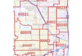
ZIP codes of Arvada, Colorado
Arvada, Colorado covers 8 Zip codes roughly. It ranges from 80001-80007,80403.The area codes are 303 and 720.
Neighborhood in Arvada, Colorado
Arvada, Colorado is considered to be a medium-sized city and offers tons of neighborhoods, parks, open spaces, and recreational opportunities. The best thing about Arvada is its prime location, located just east of the Rocky Mountains and due west of Denver. Arvada is composed of dozens of neighborhoods, Among them the most popular ones are:
- Spring Mesa
- Meadowglen
- Pomona Lakes
- Village of Five parks
- Far Horizon
- Whisper Creek
- Lake Arbor
- Candelas
- Wallace village
- Alta Vista Sub
Olde Town Arvada(Arvada Downtown)
The Olde Town Arvada historic district also known as Downtown Arvada is 7 miles(11km) northwest of Colorado State Capitol in Denver. Arvada Downtown is a 15.1 acres District in Arvada, Colorado bounded by Ralston Road, Teller Road, Grandview Avenue and Yukon Street. It was listed on the National Register of Historic Places in 1998.
| SKU | svd_co_arvada_24 |
|---|---|
| Map Scale | 1:19k |
| Flat Size | 24 x 36 in |


-
![Arvada ZIP Code Map, Colorado]() Arvada ZIP Code Map, ColoradoPrice from $41.99
Arvada ZIP Code Map, ColoradoPrice from $41.99 -
![Westminster ZIP Code Map, Colorado]() Westminster ZIP Code Map, ColoradoPrice from $41.99
Westminster ZIP Code Map, ColoradoPrice from $41.99 -
![Denver Map]() Denver MapPrice from $32.99
Denver MapPrice from $32.99 -
![Westminster Map]() Westminster MapPrice from $24.99
Westminster MapPrice from $24.99 -
![Wheat Ridge Map]() Wheat Ridge MapPrice from $24.99
Wheat Ridge MapPrice from $24.99 -
![Federal Heights Map]() Federal Heights MapPrice from $24.99
Federal Heights MapPrice from $24.99