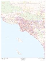
Fresno County ZIP code Map (California)
Map of Fresno County, California uses the base map data from TomTom. The data is updated every 6 months making this one of the most updated printed large map of Fresno County, CA and its neighborhood areas.
This map is available in a scale of 1:250,000 in 48 x 36 inches in landscape orientation. If you want a map with different extents, or portrait orientation, or scale, you can do that by customizing the map here.
If you have any questions, we will be happy to answer over the phone (866) 525-2298 or write to us
This map is available in 48 x 36 in. Please select a finish of your choice
Please wait, adding to your cart
Please wait, initializing the product
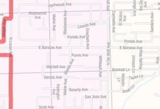
Fresno County ZIP code map overlaid on a road map features major roads, highways, neighborhood names, railways, and high-level land use such as parks, recreation areas, industrial areas, and hospital campuses. The map is ideal for planning deliveries, home services, sales territories, real estate, and much more.
This map of Fresno County, California shows ZIP code areas overlaid on a road map. Ideal for planning of deliveries, home services, sales territories, real estate and much more. Base map features include all roads with major roads and highways labelled; neighborhood names; railways; and high level land use such as parks and recreation areas, industrial areas and hospital campuses.| SKU | dmsg-county-zip-fresno-CA-1 |
|---|---|
| Map Scale | 1:250,000 |
| Flat Size | 48 x 36 in |
| Publication Date | 2019 |
| Publisher Name | MapSherpa |
Write Your Own Review
Related Products


Nearby Locations
-
![Visalia ZIP Code Map, California]() Visalia ZIP Code Map, CaliforniaPrice from $41.99
Visalia ZIP Code Map, CaliforniaPrice from $41.99 -
![Atwater ZIP Code Map, California]() Atwater ZIP Code Map, CaliforniaPrice from $41.99
Atwater ZIP Code Map, CaliforniaPrice from $41.99 -
![Auckland ZIP Code Map, California]() Auckland ZIP Code Map, CaliforniaPrice from $41.99
Auckland ZIP Code Map, CaliforniaPrice from $41.99 -
![Fresno Map]() Fresno MapPrice from $32.99
Fresno MapPrice from $32.99 -
![Visalia Map]() Visalia MapPrice from $24.99
Visalia MapPrice from $24.99 -
![Clovis ZIP Code Map, California]() Clovis ZIP Code Map, CaliforniaPrice from $41.99
Clovis ZIP Code Map, CaliforniaPrice from $41.99