Fresno Zip Code Map
This Map shows the US Zip codes written in a 5-digit format using red boundaries. These digits are divided into 3 main parts-the national areas, the region or city, and the delivery area.
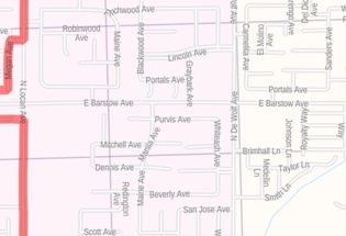
Details on Fresno City,California Zip code Map
The map includes extensive Geographic details like interstate(I-5) and state highways(Sr-41), street and street names at detailed scales, cities, and towns, counties and state names with boundaries. The map depicts a high-level land use like parks, recreation areas, industrial areas, and hospital campuses.
Major infrastructure like airports, police stations, train stations is also identifiable. Railways, ferry routes, lakes and rivers, landmarks and a variety of major points of interest are included in the map. A map legend at the bottom helps identify all signs and symbols used on the map.
Zip codes of Fresno city, California
Fresno City California roughly covers 58 Zip codes. It ranges from 93650, 93701-93794, 93844, 93888. The USPS has segmented the country into 10 Zip Code Areas they are numbered 0-9. The next two numbers of the Zip code are assigned according to the city. And the last two digits represent the area of the city or town.
Map Scale Available sizes, format, and finishes
The scale of the map is 1:30,000. The high-quality map is available in size 36x48 inches. The premium finishes available are paper, matte, plastic and canvas.
Uses of Fresno City, California Zip code Map
This map serves various travel, business, and organizational functions including service delivery, real estate, sales territories, region planning and much more. The elaborate road networks make this map an ideal tool for general reference and planning long-distance trips. The map's descriptive nature is clear and graspable which makes it apt for business and reference use.
Customization options available for this Map
We have a high-quality customizable version of this map. You can Center it around any area of your choices like a business, service area, sales territories, or your neighborhood. The zoom buttons and drag arrows on the map will help you define the print area. You can also add appropriate titles, orientations to it.
Information about Fresno City, California
Fresno is a city in and the county seat of Fresno County , California, United States. It covers about 112 Square miles (290 km2) in the center of the San Joaquin Valley, the southern portion of California’s Central Valley.
Fresno is near the geographical center of California , placing the city a comfortable distance from several of the major recreation areas and urban centers in the state. It lies approximately 220 miles (350km) north of Los Angeles, 170 miles(270 km) south of the state Capital, Sacramento , and 185 miles(300km) southeast of San Francisco . Yosemite National Park is about 60miles (100 km) to the north, Kings canyon national park is 60 miles (100 km) to the east, and Sequoia National Park is 75 miles (120 km) to the southeast.
More Maps of Fresno, California
- Central Fresno Map, California-portrait:This portrait-oriented map of central Fresno, California shows detailed street-level information.
- Central Fresno Map, California-landscape:This landscape-oriented Map of Central Fresno, California includes extensive street labeling.
- Fresno County code Map (California):The Fresno County map, California shows regional and street-level information.
Visit the online store of Maptrove.ca for more options.
| SKU | dmsg-zip-fresno-1 |
|---|---|
| Map Scale | 1:30,000 |
| Flat Size | 36 x 48 in |
| Publication Date | 2019 |
| Publisher Name | MapSherpa |